Network
A network created in ULTImodel consists of edges and nodes and is extracted from OSM and is
created using network.CreateNetwork.
Edges
Preparation: read TAZ GeoDataFrame
import network.CreateNetwork as CreateNetwork
import geopandas as gpd

taz = gpd.GeoDataFrame.from_file('DK-taz.gpkg')

taz.head()

>>> output

    nuts_id     cntr_code   nuts_name           geometry
0   DK011       DK          Byen København      MULTIPOLYGON (((12.50479 55.63734, 12.48025 55...
1   DK012       DK          Københavns omegn    MULTIPOLYGON (((12.24627 55.70664, 12.25874 55...
2   DK013       DK          Nordsjælland        MULTIPOLYGON (((12.24627 55.70664, 12.21994 55...
3   DK014       DK          Bornholm            MULTIPOLYGON (((14.88943 55.22813, 14.94373 55...
4   DK021       DK          Østsjælland         MULTIPOLYGON (((12.24627 55.70664, 12.16537 55...
Create network_edges as base for operations, based on taz:
network_edges = CreateNetwork.Edges(country='DK', taz=taz, taz_cn='cntr_code')
From taz, create country polygon(s) for network_edges. If there are islands, the country will
have multiple polygons.
polygons = network_edges.get_polygon(taz_id='nuts_id')
polygons

>>> output

        nuts_id     cntr_code   nuts_name       geometry
0   0   DK011       DK          Byen København  POLYGON ((8.19409 56.72190, 8.18723 56.75394, ...
1       DK011       DK          Byen København  POLYGON ((14.66314 55.19035, 14.66356 55.19231...
Get edges for selected OSM highway types for the polygons in polygons;
returns number of polygons with edges (not necessarily all polygons in polygons have edges)
n_poly = network_edges.get_edges(filter_highway=["motorway", "trunk", "primary"], polygons=polygons)
n_poly

>>> 2
The edges can be found in network_edges.edges
network_edges.edges.head()

>>> output

    highway     speed_kph   geometry                                            index
0   primary     63.0        LINESTRING (8.75547 55.16922, 8.75502 55.16959...   NaN
1   primary     63.0        LINESTRING (8.75547 55.16922, 8.75591 55.16884...   NaN
2   primary     80.0        LINESTRING (8.75496 55.31883, 8.75514 55.32270...   NaN
3   primary     63.0        LINESTRING (8.75496 55.31883, 8.75013 55.31339...   NaN
4   primary     63.0        LINESTRING (8.75496 55.31883, 8.76117 55.32033...   NaN
set_attributes creates a unique ID, calculates length and travel time and assigns a type number
network_edges.set_attributes(taz_id='nuts_id', start_id=1)
network_edges.edges.head()

>>> output

        highway     speed_kph   index   nuts_id     geometry                                            length      tt      ultimo_id   type
0   0   primary     63.0        NaN     DK032       LINESTRING (8.75547 55.16922, 8.75502 55.16959...   17.558210   1003.0  1           3
1   0   primary     63.0        NaN     DK032       LINESTRING (8.75547 55.16922, 8.75591 55.16884...   7.344446    420.0   2           3
2   0   primary     80.0        NaN     DK032       LINESTRING (8.75496 55.31883, 8.75514 55.32270...   2.645051    119.0   3           3
3   0   primary     63.0        NaN     DK032       LINESTRING (8.75496 55.31883, 8.75013 55.31339...   17.558210   1003.0  4           3
4   0   primary     63.0        NaN     DK032       LINESTRING (8.75496 55.31883, 8.76117 55.32033...   19.593661   1120.0  5           3
Using the nodes created based on the edges (see section Nodes), the start and end node per edge are added and the columns are reduced to the relevant info.
network_edges.set_nodes(nodes, order_col="order", linkid_col="LinkID", nodeid_col="node_id")
network_edges.edges.head()

>>> output

    ultimo_id   from_node   to_node     type    nuts_id     length  speed_kph   tt      geometry
0   1           1246        1245        3       DK032       17.558210   63.0    1003.0  LINESTRING (8.75547 55.16922, 8.75502 55.16959...
1   2           1246        1263        3       DK032       7.344446    63.0    420.0   LINESTRING (8.75547 55.16922, 8.75591 55.16884...
2   3           1245        1248        3       DK032       2.645051    80.0    119.0   LINESTRING (8.75496 55.31883, 8.75514 55.32270...
3   4           1245        1246        3       DK032       17.558210   63.0    1003.0  LINESTRING (8.75496 55.31883, 8.75013 55.31339...
4   5           1245        1399        3       DK032       19.593661   63.0    1120.0  LINESTRING (8.75496 55.31883, 8.76117 55.32033...
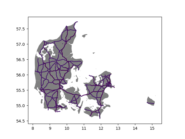
Connect subgraphs in the network (isolated networks) and remove isolated edges and nodes
to ensure that the edges are routable with connect_subgraphs. The input is either
network_edges.edges or a separate GeoDataFrame with edges and unique network nodes
nodes_unique.
final_network, final_nodes = network_edges.connect_subgraphs(nodes=nodes_unique)

>>> Connecting 8 sub graphs...

print(len(network_edges.edges), len(final_network))
final_network.head()

>>> output
3550 3538
    ultimo_id   from_node   to_node     type    nuts_id     length      speed_kph   tt      geometry
0   1           1246        1245        3       DK032       17.558210   63.0        1003.0  LINESTRING (8.75547 55.16922, 8.75502 55.16959...
1   2           1246        1263        3       DK032       7.344446    63.0        420.0   LINESTRING (8.75547 55.16922, 8.75591 55.16884...
2   3           1245        1248        3       DK032       2.645051    80.0        119.0   LINESTRING (8.75496 55.31883, 8.75514 55.32270...
3   4           1245        1246        3       DK032       17.558210   63.0        1003.0  LINESTRING (8.75496 55.31883, 8.75013 55.31339...
4   5           1245        1399        3       DK032       19.593661   63.0        1120.0  LINESTRING (8.75496 55.31883, 8.76117 55.32033...

print(len(nodes_unique), len(final_nodes))
final_nodes.head()

>>> output

    node_id     num_links   geometry
0   1           2           POINT (10.00132 55.71526)
1   2           2           POINT (10.00162 55.42639)
2   3           2           POINT (10.00209 56.44808)
3   4           2           POINT (10.00478 56.44625)
4   5           2           POINT (10.00589 57.50701)
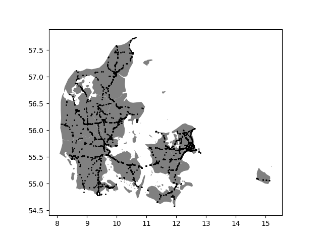
Nodes
The class Nodes in CreateNetwork creates Nodes at the ends of each edge. Using a
GeoDataFrame edges (can be created with Edges), the network_nodes instance is created.
import network.CreateNetwork as CreateNetwork
import geopandas as gpd

edges = gpd.GeoDataFrame.from_file('edges.gpkg')
edges.head()

>>> output

        highway     speed_kph   index   nuts_id     geometry                                            length      tt      ultimo_id   type
0   0   primary     63.0        NaN     DK032       LINESTRING (8.75547 55.16922, 8.75502 55.16959...   17.558210   1003.0  1           3
1   0   primary     63.0        NaN     DK032       LINESTRING (8.75547 55.16922, 8.75591 55.16884...   7.344446    420.0   2           3
2   0   primary     80.0        NaN     DK032       LINESTRING (8.75496 55.31883, 8.75514 55.32270...   2.645051    119.0   3           3
3   0   primary     63.0        NaN     DK032       LINESTRING (8.75496 55.31883, 8.75013 55.31339...   17.558210   1003.0  4           3
4   0   primary     63.0        NaN     DK032       LINESTRING (8.75496 55.31883, 8.76117 55.32033...   19.593661   1120.0  5           3
network_nodes = CreateNetwork.Nodes(edges=edges)
The initial node geometries are created with create_nodes, resulting in a GeoDataFrame
with the edge ID and position of the node (order, start or destination).
network_nodes.create_nodes(id_col="ultimo_id", geom_col="geometry")
network_nodes.nodes.head()

>>> output

    LinkID  order   geometry
0   1       0   POINT (8.75547 55.16922)
1   1       1   POINT (8.75496 55.31883)
2   2       0   POINT (8.75547 55.16922)
3   2       1   POINT (8.81108 55.11278)
4   3       0   POINT (8.75496 55.31883)
To remove duplicates, the coordinates of all the start and end nodes are compared in
remove_duplicates and a GeoDataFrame with all unique nodes is produced.
network_nodes.remove_duplicates()
network_nodes.nodes_unique.head()

>>> output

    xy                                          num_links   geometry
0   [(10.001318200000002, 55.715256698015416)]  2           POINT (10.00132 55.71526)
1   [(10.001617600000001, 55.42638559797401)]   2           POINT (10.00162 55.42639)
2   [(10.002085100000008, 56.44808009811454)]   2           POINT (10.00209 56.44808)
3   [(10.004784400000002, 56.446253498114366)]  2           POINT (10.00478 56.44625)
4   [(10.005892199999995, 57.50701369824364)]   2           POINT (10.00589 57.50701)
Based on these unique nodes, IDs are created in set_node_id.
network_nodes.set_node_id(id_col='node_id', start=1)
network_nodes.nodes_unique.head()

>>> output

    node_id     num_links   geometry
0   1           2   POINT (10.00132 55.71526)
1   2           2   POINT (10.00162 55.42639)
2   3           2   POINT (10.00209 56.44808)
3   4           2   POINT (10.00478 56.44625)
4   5           2   POINT (10.00589 57.50701)

---

network_nodes.nodes.head()

>>> output

    node_id     LinkID  order   geometry
0   1246        1       0       POINT (8.75547 55.16922)
1   1245        1       1       POINT (8.75496 55.31883)
2   1246        2       0       POINT (8.75547 55.16922)
3   1263        2       1       POINT (8.81108 55.11278)
4   1245        3       0       POINT (8.75496 55.31883)
Connectors
Preparation: read TAZ GeoDataFrame and population GeoDataFrame
import network.CreateNetwork as CreateNetwork
import geopandas as gpd

taz = gpd.GeoDataFrame.from_file('DK-taz.gpkg')

taz.head()

>>> output

    nuts_id     cntr_code   nuts_name           geometry
0   DK011       DK          Byen København      MULTIPOLYGON (((12.50479 55.63734, 12.48025 55...
1   DK012       DK          Københavns omegn    MULTIPOLYGON (((12.24627 55.70664, 12.25874 55...
2   DK013       DK          Nordsjælland        MULTIPOLYGON (((12.24627 55.70664, 12.21994 55...
3   DK014       DK          Bornholm            MULTIPOLYGON (((14.88943 55.22813, 14.94373 55...
4   DK021       DK          Østsjælland         MULTIPOLYGON (((12.24627 55.70664, 12.16537 55...

# read population
pop = gpd.GeoDataFrame.from_file('4326-points-population.gpkg')

pop.head()

>>> output

    VALUE       cntr_code   geometry
0   0.000000    DK          POINT (12.52891 55.58360)
1   0.063969    DK          POINT (12.53872 55.58360)
2   0.063969    DK          POINT (12.54852 55.58360)
3   0.000000    DK          POINT (12.55832 55.58360)
4   1152.648    DK          POINT (12.56812 55.58360)
Initialize the connector class with
conn_ = CreateNetwork.Connectors()
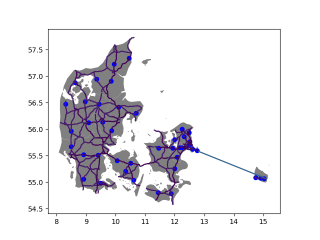
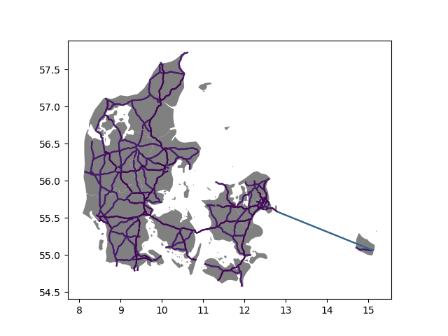
Determine population centers
conn_.find_connector_locations(taz, pop, taz_geom='geometry')
conn_.connectors.head()

>>> output

    nuts_id     c_n     weight      geometry
0   DK011       0       0.000048    POINT (12.76171 55.63546)
1   DK011       1       0.785301    POINT (12.53487 55.68012)
2   DK011       2       0.214651    POINT (12.60310 55.61478)
0   DK012       3       0.493351    POINT (12.39750 55.67478)
1   DK012       4       0.103410    POINT (12.24445 55.65573)
Move population centers to network nodes
nodes = gpd.GeoDataFrame.from_file('unique-nodes.gpkg')
# add country code to nodes
nodes['cntr_code'] = 'DK'

>>> output

    node_id     num_links   geometry
0   1           2   POINT (10.00132 55.71526)
1   2           2   POINT (10.00162 55.42639)
2   3           2   POINT (10.00209 56.44808)
3   4           2   POINT (10.00478 56.44625)
4   5           2   POINT (10.00589 57.50701)

all_conn = conn_.identify_connector_nodes(nodes=nodes, zone='nuts_id', weight="weight", country_check='cntr_code')
all_conn.head()

>>> output
No duplicates detected!
    node_id     geometry                    nuts_id     c_n     weight
0   1095        POINT (12.74977 55.60094)   DK011       0       0.000048
1   1014        POINT (12.51936 55.70192)   DK011       1       0.785301
2   1078        POINT (12.60314 55.62947)   DK011       2       0.214651
3   890         POINT (12.39536 55.67467)   DK012       3       0.493351
4   777         POINT (12.23742 55.65711)   DK012       4       0.103410